82.15 km
COMPLETE CORRIDOR
Sarai Kale Khan to Modipuram
23
ROUTE STATIONS
Stations shown in the journey planner
25
CORRIDOR STATIONS
Including two depot stations
4
SHARED STATIONS
Namo Bharat + Meerut Metro
📍 Complete Delhi-Meerut Corridor:
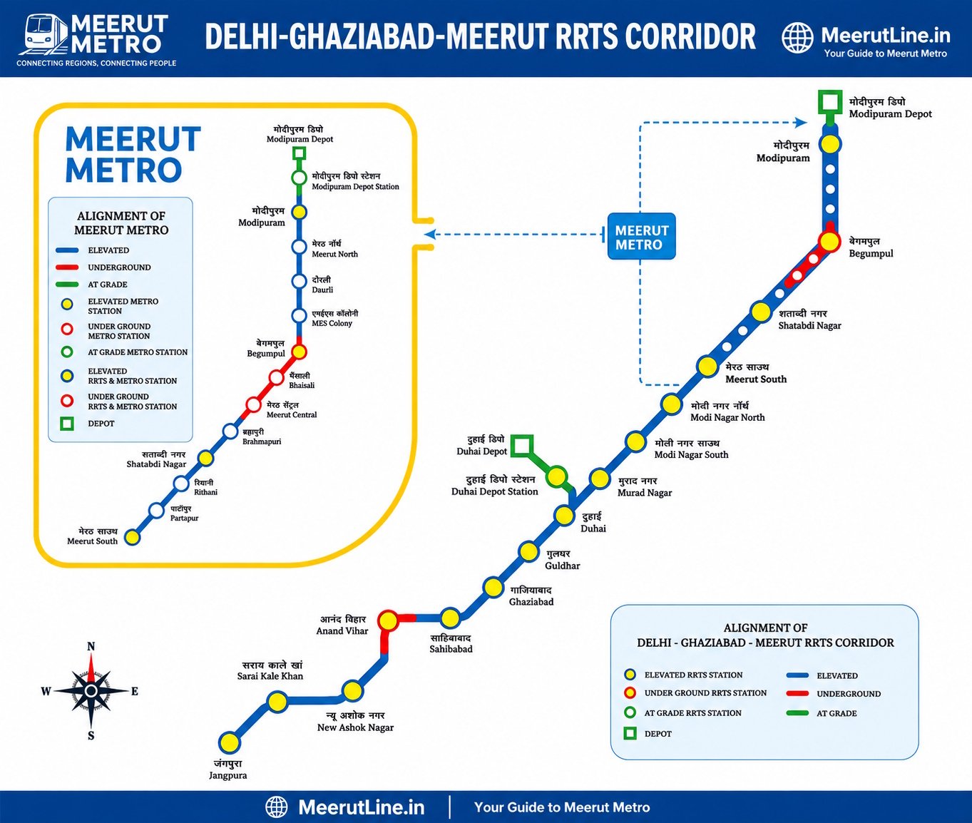
The Delhi-Ghaziabad-Meerut Namo Bharat corridor runs from
Sarai Kale Khan, Delhi to Modipuram, Meerut.
The full 82.15 km corridor became operational on 22 February 2026.
The corridor has 25 stations including two depot stations, while the public journey
planner lists 23 route stations for passenger journeys.
🚄 Complete Station List & Services
The public Namo Bharat journey planner lists 23 route stations from Sarai Kale Khan
to Modipuram. The wider corridor count is 25 when the two depot stations are included.
In Meerut, Namo Bharat and Meerut Metro share infrastructure at four stations.
🚆
Namo Bharat Route Stations
Regional services from Delhi to Meerut
01 Sarai Kale Khan Z00
02 New Ashok Nagar A01
03 Anand Vihar A02
04 Sahibabad A03
05 Ghaziabad A04
06 Guldhar A05
07 Duhai A06
08 Murad Nagar A07
09 Modi Nagar South A08
10 Modi Nagar North A09
11 Meerut South A10
12 Shatabdi Nagar A13
13 Begumpul A17
14 Modipuram A21
🚇
Meerut Metro Stations
Local Metro service in Meerut
01 Partapur A11
02 Rithani A12
03 Shatabdi Nagar A13
04 Brahampuri A14
05 Meerut Central A15
06 Bhaisali A16
07 Begumpul A17
08 MES Colony A18
09 Daurli A19
10 Meerut North A20
11 Modipuram A21
12 Meerut South A10
Meerut Metro has 13 stations in total. Four of them also serve Namo Bharat,
creating shared regional and local connectivity.
🔄
Shared Namo Bharat + Meerut Metro Stations
Four stations serve both services
01
Meerut South
02
Shatabdi Nagar
03
Begumpul
04
Modipuram
These four stations provide the shared infrastructure that allows regional
Namo Bharat and local Meerut Metro services to connect on the same network.
🏭 Depot & Stabling Facilities
Duhai Depot
Depot facility on the Delhi-Ghaziabad-Meerut corridor
Modipuram Depot
Meerut-end depot associated with the corridor
Jangpura Stabling Yard
Stabling and maintenance facility in Delhi
🛤️ Delhi-Ghaziabad-Meerut Corridor: Key Information
📍 Route
Sarai Kale Khan, Delhi → Modipuram, Meerut
📏 Length
82.15 km
🏙️ Cities Connected
Delhi, Ghaziabad and Meerut
⏱️ Delhi to Meerut
Under 60 minutes
🚆 Namo Bharat
Regional rapid transit service
🚇 Meerut Metro
Local transit service using shared infrastructure in Meerut
📅 Full Operations
22 February 2026
🏗️ Alignment
69.79 km elevated and 12.36 km underground
Official source:
National Capital Region Transport Corporation (NCRTC).
Figures and station information are based on NCRTC's published corridor,
map and station information.
📏 Route Distance Reference
The complete Delhi-Ghaziabad-Meerut corridor is 82.15 km long.
For station-to-station distance and fare calculations, use the
Route Finder on MeerutLine.in.
| Route / Section |
Distance |
Information |
| Sarai Kale Khan → Modipuram |
82.15 km |
Complete Corridor |
| Meerut South → Modipuram |
Approx. 23 km |
Meerut Metro |
| Elevated section |
69.79 km |
Corridor Alignment |
| Underground section |
12.36 km |
Corridor Alignment |
💡 Travel tip: Use the Route Finder to select any two stations
and view the available route, distance, travel time and fare information.
📥 Download Metro Map
Get the metro map for offline reference
Plan Your Journey
Use our tools to find routes,
calculate fares, and check timings